
Gypsum Creek Ranch (CO47)
Background: The Gyspum Creek Ranch is located on private land 3.5 miles south of the Gypsum, Colorado in the shadows of the Eagle County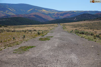 Airport (KEGE). The ranch and airstrip were founded by pilot and aviation enthusiast Ned Goldsmith in the late 1980s. One of the original homestead cabins from the late 1800s can still be seen near the parking area on the North end of the airstrip. Ned was a naval aviator who served on the USS Lexington and flew Sikorsky H-34 helicopters in the Antarctic out of McMurdo Station. He took great joy in developing the airstrip and seeing it in use. Ned’s daughter Carrie and husband Greg carry on that legacy today, graciously allowing continued recreational access to this private airstrip.
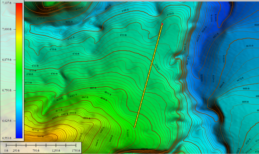
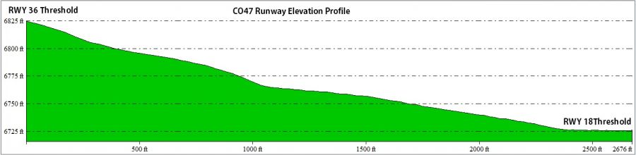
Airstrip Overview: The gravel runway is located on a ridge above and west of the main ranch property at an elevation of approximately 6,800 ft. Mountainous terrain exists in all quadrants. The primary runway heading is 18/36 and has a useable length of 2,650 ft. The runway is narrow with a variable width of 30 ft. which is an important consideration for crosswind operations. A 4.0 % downhill gradient exists from South to North. Preferred operations are to land uphill on Runway 18 and depart Runway 36 downhill. At the time of this publication, a windsock is not available. Aircraft parking is available on the NE corner of the airstrip near the homestead cabin. No tiedowns or anchors are available, so bring your own.
LAND AT YOUR OWN RISK - The runway is not actively maintained. Gypsum Creek Ranch is an active cattle farm and therefore livestock, irrigation equipment, and vehicles may be on or near the runway.
Image - Runway overlay on terrain contour map:
CO47 ARP Coordinates:
LAT: 39° 35' 52.89" N
LONG: 106° 58' 28.22" W
Note: The FAA airport/runway data for CO47 is out of date. A recent Magnetic Variation change to 9E has occurred and the runway magnetic headings have changed from 03/21 to 18/36.
Aircraft Performance: Check Density Altitude. Given the high runway gradient and preferred landing directions, there is a good chance you’ll experience crosswind or tailwinds during take-off or landing. Combined with the high elevation of the airport, it’s important that the PIC ensure the aircraft has the necessary performance given the current temperature, wind component, and obstacle clearance. Consult the aircraft POH/AFM or a qualified flight instructor if unsure.
 Obstacles: The Runway 18 Threshold (North End) has a 5 ft. AGL entrance gate at the start of the runway. When Landing RWY 18, displace your landing to clear this obstacle. The immediate runway is otherwise clear of obstructions other than an abandoned cabin and power pole at a distance of 400 ft. from the RWY 18 landing threshold and 300’ East of centerline. Go Arounds to the South require a climbing -LEFT- turn to avoid rising mountainous terrain.
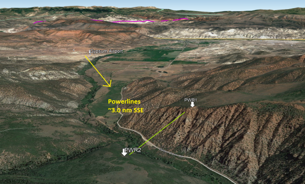
Warning: When flying in the area, use extreme caution for a suspended powerline 3.0nm SSE of the airfield above Gypsum Creek Road at the entrance to the canyon.
Weather Information: The nearest weather station is at the Eagle County Airport. The frequency is 135.575. Winds at the airstrip are highly variable due to terrain features surrounding the airport. Prevailing winds in the area are usually from the west.
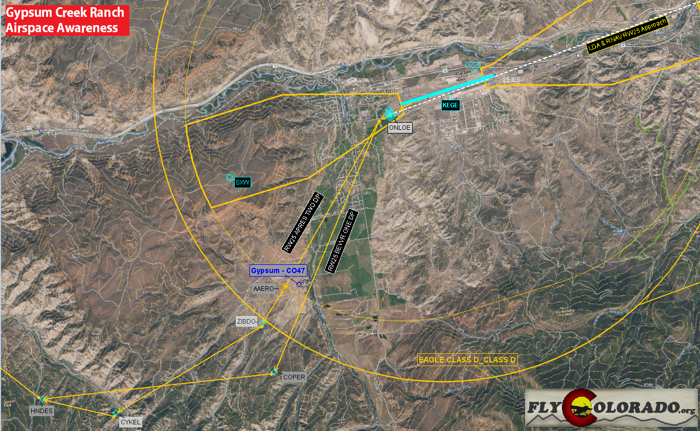
Airspace Awareness: The Gypsum Creek airport is located within Eagle County Airport’s Class Delta Airspace which extends from the surface to 9,100 ft. Communication with the Eagle Control Tower on frequency 119.80 is mandatory for arrival and departure. It’s recommended giving the tower a call 5-10nm prior to arrival to allow enough time for coordination of traffic. In addition, announce intentions on 122.90. The tower and ATIS frequency are receivable while on the ground at Gypsum Creek. Request Departure clearance from Eagle Tower prior to departure. If radio reception is poor, taxi to the South end of the airstrip (RWY 36 THR) where the ground is higher.
Enhanced Traffic Awareness:
Eagle Departures: The Gypsum Creek Ranch sits directly below the departure path of nearby Eagle County Airport (KEGE). Aircraft ranging from business jets to Boeing 757s are utilizing this departure corridor at low altitudes over the Gypsum Ranch.
Eagle Arrivals: While approaching and transitioning through the Class D, it’s important to be aware that large aircraft are usually landing utilizing the Runway 25 LDA approach in to Eagle County. Light GA aircraft are also performing pattern operations (ex. Touch and goes) to the South of Eagle airport. Be sure to give enough spacing and follow ATC instructions.
Please view the airspace map below to help plan your arrival and departures:
Camping: There is no lodging for rent at Gypsum Creek Ranch, but camping is allowed on request. Permission is required, so please contact the ranch owners for further details.
Contact Information:
Greg & Carrie: (207) 251-one-two-51 or (303) 886-nine two-24
Note: Keep in mind the owners are not pilots. They can provide basic details about runway conditions and camping, but it’s the PIC’s responsibility to seek additional details about take-off and landing techniques and local best practices from a qualified flight instructor.
Photos from Gypsum Creek Ranch Airport:


